Mauritius Weather: Current Status of Tropical Cyclone 16S and Forecast Analysis
Cyclone Update: 19 Feb at 10:42 am MUT(GMT+4hrs), 6:42 am GMT, 12:42pm BST(GMT+6hrs)
Tropical Cyclone 16S, also known as Sixteen, is currently located approximately 348 nautical miles north-northwest of Port Louis, Mauritius.
Over the past six hours, it has been moving east-northeastward at a speed of 10 knots, with a minimum central pressure of 999 mb and maximum significant wave height of 14 feet.
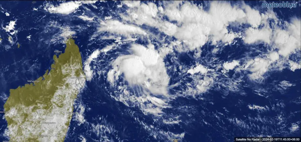
Current Satellite Image of Cyclone 16S: Tropicaltidbits
Satellite Analysis and Initial Intensity Discussion:
The cyclone is rapidly consolidating, although it may appear somewhat disorganized in the low-levels compared to its appearance in infrared imagery.
There’s a visible dense overcast feature developing, but cloud tops are warming, and cirrus debris is shearing off to the east.
Despite this, there are signs of strengthening, with a hot tower flaring up near the low-level circulation center. However, the system remains relatively small and tilted, making it susceptible to slight mid-level westerly shear.
Current Environment Assessment based on Mauritius Weather:
The cyclone is benefiting from a favorable environment characterized by warm sea surface temperatures, high ocean heat content, low vertical wind shear, and good dual-channel outflow. However, its small size and slight tilt may pose challenges in intensification.
Cyclone 16S Track Forecast: JTWC
Forecast Discussion:
The cyclone is expected to continue tracking eastward along the southern side of a strong northeast ridge for the first 24 hours.
Beyond that, the ridge weakens, and the cyclone is forecasted to turn sharply southward between hours 36 and 48. Subsequently, it will track south-southwestward towards the Mascarene Islands, following a complex ridge pattern in the central Indian Ocean.
By the end of the forecast period, weakening steering currents may lead to a slower track and a westward turn.
See Also: Cyclone Lincoln: May Re-intensify Wednesday off Kimberley Coast
More: Cyclone Lincoln: Severe Weather Warning for NT and Kimberley Region
Model Discussion and Forecast Confidence:
Model guidance shows significant spread, particularly after hour 48, making the forecast uncertain. Intensity guidance is also mixed, with some models predicting rapid intensification, while others suggest more modest strengthening.
Confidence in both the track and intensity forecasts remains low throughout the forecast period.
Summary of This Update:
Tropical Cyclone 16S presents uncertainties in its future track and intensity, emphasizing the importance of continued monitoring and updates from meteorological authorities.
Residents in the affected regions should stay informed and follow any advisories issued by relevant authorities to ensure safety and preparedness.
Advertisements