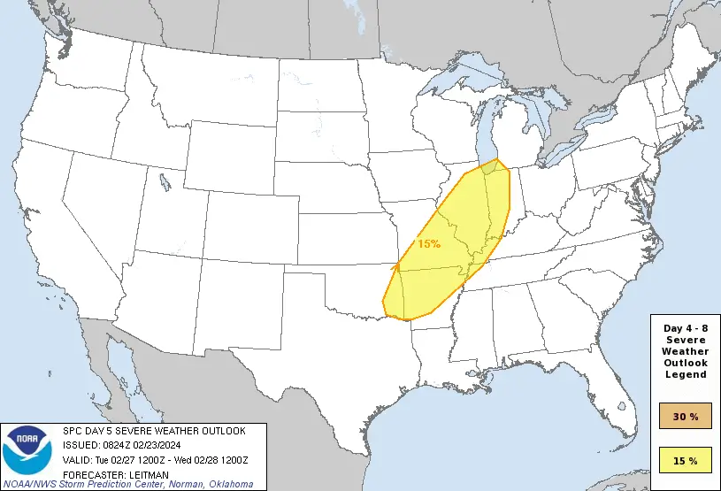
Severe Weather: Central U.S. Braces for Storms
Issue Date: February 23, 2024 at 02:24 AM Central Standard Time (CST)
Valid for: 26 February to 01 March 2024
As the week progresses, the central United States is bracing for potential severe weather, with the National Weather Service’s Storm Prediction Center issuing a convective outlook spanning from Day 4 to Day 8.
The forecast indicates the likelihood of organized thunderstorms and accompanying severe risks. Which driven by a combination of atmospheric dynamics and evolving synoptic patterns.
So, Severe Weather Outlook suggests that Central U.S. Braces for Storms Tuesday into Wednesday.
Day 4-5: Setting the Stage for storms for Central US
Beginning on Day 4 (Monday) and extending into Day 5 (Tuesday), a potent setup emerges. Strong winds are blowing high up in the sky from the south over the southern United States.
At the same time, a big dip in the high-up winds is forming in the north, stretching from the Pacific Northwest down to the northern and central High Plains.
This juxtaposition sets the stage for increasing southerly low-level flow, facilitating airmass modification and moisture advection from the Gulf of Mexico northward into the Mid-Mississippi Valley.
Day 5-6: Heightened Severe Weather Potential
By Day 5 (Tuesday) afternoon, the convergence of improved boundary-layer moisture and an EML (Elevated Mixed Layer) with steep midlevel lapse rates over the central U.S. creates conditions ripe for at least modest destabilization.
Surface instability uncertain due to low moisture. Favorable vertical shear present. Additionally, A surging cold front strengthens the risk of severe storms. So, Central U.S. is at risk on that day.
Day 5 Severe Weather Warning: National Weather Service
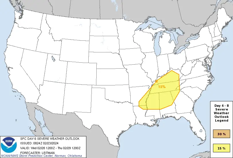
Day 6: Uncertainty and Trimmed Probabilities
Uncertainty looms as the system progresses into Day 6 (Wednesday), particularly regarding the timing of the surface cold front’s eastward movement.
Divergence between forecast models, notably the ECMWF and GFS, complicates the outlook. While the operational GFS indicates a slower progression of the front, ensemble guidance from the GEFS suggests a faster movement.
In response to this uncertainty and evolving trends, severe probabilities for Day 6 are maintained but trimmed, reflecting the dynamic nature of the forecast.
Day 5 Severe Weather Warning: National Weather Service
Beyond Day 6: Increasing Uncertainty in the Forecast
Looking beyond Day 6, forecast guidance exhibits heightened spread, with predictability diminishing. The evolving synoptic pattern introduces complexities that challenge forecasters. Undoubtedly, underscoring the need for ongoing monitoring and adaptation to changing conditions.
See Also: Re-intensification of Ex Tropical Cyclone Lincoln posing Threat to WA
Forecast Summary of Central US
In summary, the central U.S. faces a heightened risk of severe weather from Day 5 to Day 6, driven by dynamic atmospheric conditions and the interaction of various synoptic features.
While uncertainty persists, forecasters emphasize the importance of vigilance and readiness in response to evolving weather patterns.
As the situation unfolds, continued monitoring and adjustments to forecasts will be imperative to mitigate potential impacts and ensure public safety.
Check Official forecast here in NWS Website
Advertisements