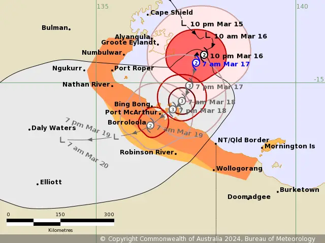
Cyclone Megan: Monster Cyclone Megan Developing across Gulf of Carpentaria
Tropical Cyclone Advisory: 9:00 am ACST [9:30 am AEST] on Saturday,17 March 2024
Unfortunately, Tropical Cyclone Megan is intensifying rapidly in the Gulf of Carpentaria. Potentially Monster Cyclone Megan may cross the coast at peak intensity. It is prompting warnings and watches for various regions along the northern Australian coast. As the cyclone gains monster strength, residents are urged to prepare and stay informed about potential hazards.
Areas To be affected by Monster TC Megan:
TC Megan Warning Zone: Includes Alyangula (Groote Eylandt) in NT to Mornington Island in QLD. Also it is including Borroloola but excluding Ngukurr or Mornington Island.
TC Megan Watch Zone: Mornington Island in Qld as well as adjacent parts of the Carpentaria District inland to Robinson River in NT.
Cancelled Zone: No cancellations reported.
Details of Tropical Cyclone Megan
Intensity: Currently classified as Category 2 (AU Scale). Maximum sustained winds near the center reaching 110 km/h (10min) and gusts up to 155 km/h.
Location: Positioned within 35 kilometres of 14.5 degrees South 137.5 degrees East, estimated to be 135 kilometres east southeast of Alyangula and 215 kilometres northeast of Borroloola.
Movement: Slow-moving trajectory towards south.
Megan Forecast and Hazards for Northern Australia:
Tropical Cyclone Megan is projected to strengthen rapidly as it heads southward over this weekend. It may potentially escalate to Category 3 (AU Scale) by this evening.
Furthermore, Megan is expected to cross the coast during Monday or early Tuesday morning as a Monster Tropical Cyclone. Landfall point could be between Nathan River and the Northern Territory/Queensland border. Once over land, Megan should weaken quickly as it tracks west through the Northern Territory.
Wind Data of TC Megan
Damaging Wind Gusts: Residents in eastern Groote Eylandt are currently being experienced Gales with DAMAGING WIND GUSTS of 110 km/h.
Gales with DAMAGING WIND GUSTS of 100 km/h are expected to develop between Numbulwar in the Northern Territory and Mornington Island in Queensland, including Borroloola, during the day. Gales may extend inland to Robinson River overnight Sunday into Monday if the system moves more quickly to the south.
Destructive Wind Gusts: Particularly severe winds, exceeding 125 km/h are likely about the southwestern Gulf of Carpentaria coast, near the system centre, from later today.
Very Destructive Core: The VERY DESTRUCTIVE CORE of Tropical Cyclone Megan with wind gusts up to 200 km/h is expected to cross the coast between Nathan River in the Northern Territory and the Northern Territory/Queensland border during Monday or early Tuesday morning.
There is a slight risk of gales with DAMAGING WIND GUSTS of 100 km/h on Mornington Island itself on Monday, if the system tracks further east than forecast.
Intense Rainfall Warning
Intense Rainfall: As well as INTENSE RAINFALL is possible about Groote Eylandt and coastal parts of the Carpentaria District during the weekend.
HEAVY RAINFALL is occurring over eastern parts of the Top End, with the heaviest falls in coastal and island locations. The heaviest falls will extend further inland during today, into the Carpentaria forecast district as well as into parts of the Gulf Country coast in Queensland.
Storm Tide and Abnormally High Tides Warning:
Additionally, Coastal residents between Nathan River and the Northern Territory/Queensland border are specifically warned of a DANGEROUS STORM TIDE as the cyclone centre crosses the coast. Tides are likely to rise significantly above the normal high tide, with DAMAGING WAVES and DANGEROUS FLOODING.

Read More:
Cyclone Megan: Cyclone Threat for Coasts across Gulf of Carpentaria
Auckland Weather: What To Expect Next Week?
Recommended Action to Overcome the Cyclone Megan Impact:
Residents in the Cyclone Warning area are advised by the Northern Territory Emergency Service to enact household plans. Also secure properties, stay informed, and exercise caution on roads. Additionally, Those within the Cyclone Watch area should prepare, stay informed, and closely monitor evolving conditions.
At the same time, QFES advises residents between the QLD/NT border and Mornington Island to take necessary precautions, while residents on Mornington Island should consider potential actions in response to escalating cyclone threats.
If You are in an old update, Check new updates here (Click Me)
Advertisements