Cyclone Megan: Cyclone Threat for Coasts across Gulf of Carpentaria
Tropical Cyclone Advisory: 8:20 pm ACST [8:50 pm AEST] on Saturday 16 March 2024
Finally, Tropical Cyclone Megan has emerged in the Gulf of Carpentaria. It is prompting warnings and watches for various regions along the northern Australian coast. As the cyclone gains strength, residents are urged to prepare and stay informed about potential hazards.
Areas To be affected by Megan:
TC Megan Warning Zone: Includes Alyangula (Groote Eylandt) in NT to Mornington Island in QLD, covering Borroloola but excluding Ngukurr or Mornington Island.
TC Megan Watch Zone: Encompasses Mornington Island in QLD and adjacent parts of the Carpentaria District inland to Robinson River in NT.
Cancelled Zone: No cancellations reported.
Details of Tropical Cyclone Megan
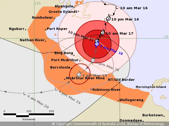
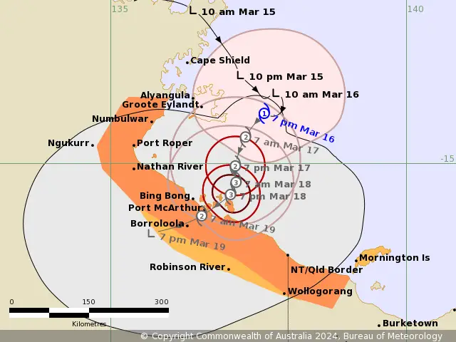
Intensity: Currently classified as Category 1 (AU Scale). Maximum sustained winds near the center reaching 85 km/h (10min) and gusts up to 120 km/h.
Location: Positioned within 30 kilometers of 14.2 degrees South 137.8 degrees East. Which is approximately 150 kilometers east-southeast of Alyangula and 260 kilometers northeast of Borroloola.
Movement: Slow-moving trajectory anticipated.
Cyclone Megan Forecast and Hazards for Northern Australia:
Tropical Cyclone Megan is projected to strengthen further as it heads southward over the weekend. It may potentially escalate to Category 2 (AU Scale) by tonight. Also, it may reach Category 3 (AU Scale) by Sunday night before making landfall on Monday.
Damaging Wind Gusts: Residents in Groote Eylandt face the possibility of gales with gusts up to 110 km/h, extending into Sunday. Areas between Numbulwar in NT and Mornington Island in Qld may experience gusts up to 100 km/h overnight tonight or on Sunday. Moreover, It may extend inland to Robinson River if the cyclone accelerates southward.
Destructive Wind Gusts: Particularly severe winds, exceeding 125 km/h, are expected along the southwestern Gulf of Carpentaria coast from late Sunday.
Very Destructive Core: Landfall between Nathan River in NT and the QLD/NT border is anticipated from early Monday. Hence, It may accompanied by wind gusts reaching up to 185 km/h.
Intense Rainfall: As well as Heavy rainfall forecasted over Groote Eylandt and coastal areas of the Carpentaria District throughout the weekend.
Storm Tide and Abnormally High Tides: Additionally, Southern Gulf of Carpentaria coast may face storm tide conditions, resulting in abnormally high tides and potential minor flooding along the foreshore.

Read More:
Multiple Lows Are Intensifying to Affect Australian Coasts
Tropical Low: Two Systems Pose Potential Threats to Australian Coasts
Recommended Action to Overcome the Cyclone Megan Impact:
Residents in the Cyclone Warning area are advised by the Northern Territory Emergency Service to enact household plans. Also secure properties, stay informed, and exercise caution on roads. Additionally, Those within the Cyclone Watch area should prepare, stay informed, and closely monitor evolving conditions.
At the same time, QFES advises residents between the QLD/NT border and Mornington Island to take necessary precautions, while residents on Mornington Island should consider potential actions in response to escalating cyclone threats.
If You are in an old update, Check new updates here (Click Me)
Advertisements