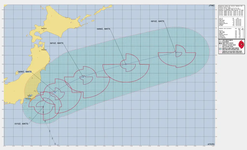
Tropical Storm Krosa Update – July 1, 2025, 3 PM UTC
The Joint Typhoon Warning Center (JTWC) has issued Prognostic Reasoning Warning Number 36 for Tropical Storm 12W (Krosa) as of 3 PM UTC, July 1, 2025. The storm is located southeast of Yokosuka, Japan, and is forecast to begin extratropical transition within the next 48 hours as of Tropical Storm Krosa Latest Update
Current Position and Movement as of Tropical Storm Krosa Update
-
Location: 34.3°N, 141.3°E
-
Distance: About 183 km southeast of Yokosuka, Japan
-
Recent Movement: Northward at 11 km/h (past 6 hours)
-
Significant Wave Height: 7.6 meters
Current Intensity and Atmospheric Conditions
-
Maximum Sustained Winds: 111 km/h (60 knots)
-
Wind Environment: Moderate poleward outflow
-
Sea Surface Temperature: 27–28°C
-
Vertical Wind Shear: Moderate (19–28 km/h)
Satellite imagery indicates building deep convection obscuring the low-level circulation center (LLCC). Radar also confirms cloud banding wrapping into the center, suggesting continued organization despite marginal environmental conditions.
Steering and Synoptic Features as of Tropical Storm Krosa Latest Update
Krosa is currently influenced by a Near Equatorial Ridge (NER) positioned to the southeast, steering it slowly northeastward. Within the next 12 hours, an approaching deep-layer trough from the northwest will accelerate Krosa’s track toward the northeast.
Forecast Track and Intensity Outlook of Tropical Storm Krosa
0–12 Hours
-
The storm will maintain current intensity (~111 km/h winds) over warm waters of the Kuroshio Current.
-
Movement will remain slow but begin curving northeastward.
12–36 Hours
-
Increasing vertical wind shear and dry air entrainment will initiate weakening.
-
Forward speed will increase as it interacts with the trough from the northwest.
36–48 Hours
-
Krosa will undergo extratropical transition, becoming baroclinic and frontal in structure.
-
Winds are expected to drop to ~93 km/h (50 knots) by the end of the forecast period.
Model Guidance and Confidence as of Tropical Storm Krosa Latest Update
-
Track Confidence: Medium – Most models agree on the northeastward track, except for NAVGEM, which is farther north. Cross-track spread is 110 km or less by 48 hours.
-
Intensity Confidence: Medium – Good agreement on gradual weakening, with final extratropical strength around 45–50 knots (83–93 km/h).
Follow us on Google News feed for daily Latest Updates
Hazards Affecting Japan by Tropical Storm Krosa
-
Heavy Rain and Strong Winds: Coastal areas of Honshu, particularly near Yokosuka and Tokyo Bay, may experience heavy rainfall and gusty winds over the next 24–36 hours.
-
High Seas: Wave heights near 7–8 meters pose risks to marine and shipping interests in the region.
-
Transition Phase: Impacts will shift from tropical to extratropical, but strong winds and heavy rainfall will persist.
Key Details
-
Storm Name: Tropical Storm Krosa (12W)
-
Location: 183 km SE of Yokosuka, Japan
-
Wind Speed: 111 km/h, gusting higher
-
Movement: North at 11 km/h
-
Forecast: Transition to extratropical by 36–48 hours
Update Time: July 1, 2025, 3 PM UTC
Source: Joint Typhoon Warning Center (JTWC) – Prognostic Reasoning Warning 36
Stay tuned to local meteorological agencies and official advisories for the latest updates on Tropical Storm Krosa’s impacts.
If You are in an old update, Check new updates here (Click Me)
Advertisements