Tropical Cyclone Fina Latest : Cyclone Fina (05S) Intensifies While, Drifting Toward Northern Territory Coast, Australia
Time: 200900Z (20 November 2025, 06:30 PM ACST – Australian Central Standard Time) – Cyclone Fina Latest Update
Tropical Cyclone Fina (05S) continues to slowly organize as it moves gradually toward northern Australia. According to the latest analysis from the Joint Typhoon Warning Center (JTWC), the storm remains a strong tropical cyclone positioned northeast of Darwin while encountering a mixed set of atmospheric conditions that are slowing its development but not preventing gradual intensification.
This long-duration system is showing signs of structural improvement, although dry air entrainment and moderate wind shear remain limiting factors. The latest warning and forecast data provide important insight into the cyclone’s expected track, intensity changes, and landfall potential in the coming days.
Current Situation and Storm Analysis as of Cyclone Fina Latest Update
Location and Movement
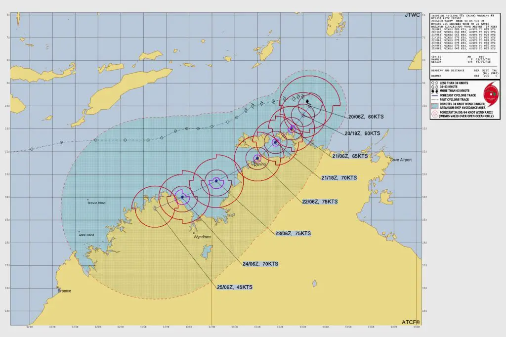
As of 200600Z, Tropical Cyclone Fina is located near 10.0°S, 133.3°E, which places the storm approximately 206 nautical miles northeast of Darwin, Australia. Over the past six hours, the cyclone has been moving south-southeastward at a very slow speed of 2 knots, indicating a system still searching for stronger steering flow.
Intensity and Structure
The cyclone’s maximum sustained winds remain at 60 knots (111 km/h) with gusts reaching 75 knots (139 km/h). The minimum central pressure reported is 983 mb. Significant wave heights near the center are estimated at 18 feet (5.4 meters).
Satellite analysis shows ongoing structural challenges. Animated multispectral imagery reveals warming cloud tops and increasing exposure of the low-level circulation center (LLCC) due to northeasterly pressure gradients and moderate shear. Microwave imagery from a 200438Z AMSR2 89 GHz pass confirms a clearly defined center with most deep convection displaced westward.
JTWC assesses the initial intensity with low confidence, as various satellite-derived estimates range widely from 49 knots to 79 knots. The official estimate of 60 knots aligns most closely with CIMSS SATCON values and subjective Dvorak assessments.
Environmental Conditions as of Cyclone Fina Latest Update
Tropical Cyclone Fina currently exists within a marginally favorable environment, characterized by:
- Vertical Wind Shear (VWS): 15–20 knots of northeasterly shear
- Sea Surface Temperatures: Warm waters between 29°C and 30°C
- Outflow: Moderate poleward and equatorward ventilation
- Dry Air: Significant dry air entrainment over the eastern semicircle
The surrounding steering flow is being controlled by the southwestern periphery of a near-equatorial ridge centered northeast of Papua New Guinea. This ridge is expected to influence the cyclone’s movement over the next five days.
The initial position is judged with medium confidence, while both wind radii and intensity assessments carry low confidence due to the storm’s asymmetric structure and mixed environmental signals.
Forecast Track and Landfall Timeline of Cyclone Fina as of Latest update
No Major Changes in Forecast Philosophy
The JTWC notes that there are no significant deviations from the previous forecast scenario. The upcoming days will involve multiple interactions with land as the storm tracks closer to northern Australia.
Expected Track Through 120 Hours
TC Fina is forecast to begin tracking southwestward as the subtropical ridge strengthens south of the Gulf of Carpentaria. This motion is expected to continue throughout the forecast period.
The system is projected to make three separate landfalls:
- First Landfall (Around TAU 30hrs)
- Location: Near Garig Gunak Barlu National Park (Cobourg Peninsula)
- The cyclone will cross the first stretch of land before entering the Van Diemen Gulf.
- Second Landfall (Near TAU 48–60hrs)
- Location: Near Darwin, as the system skirts along the northern coast
- Brief weakening is expected due to land interaction.
- Third Landfall (Just After TAU 96hrs)
- Location: East of Kalumburu in Western Australia
- Increasing shear (20–25 knots) and land interaction will then cause steady weakening.
Intensity Forecast as of Cyclone FINA Latest update
- TC Fina is expected to maintain its current strength for the next 12 hours, as dry air and shear remain dominant factors.
- Between TAU 12 and TAU 48, the shear is expected to relax slightly, allowing marginal intensification. The cyclone may strengthen to 70–75 knots (130–139 km/h) during this window.
- After TAU 48, land proximity and uneven environmental support will cause fluctuations.
- Beyond TAU 72, increased northwesterly shear and more land interaction will significantly limit intensification potential.
- After the third landfall, the system will rapidly weaken over land.
Model Guidance and Confidence Levels as of Cyclone Fina Latest update
Numerical models offer good agreement through TAU 72, showing a tight cluster with a 90-nautical-mile cross-track spread. Beyond TAU 72, however, solutions diverge significantly, with model spread increasing to 210 nautical miles by TAU 120.
- NAVGEM represents the southernmost track scenario.
- GALWEM is the northernmost model.
- JTWC aligns closely to consensus through 72 hours and shifts toward GDM and ECMWF ensemble means afterward.
Intensity Model Spread
There is poor agreement among intensity models:
- Some guidance supports gradual intensification.
- Others show steady weakening due to land interaction and shear.
- HAFS-A is a significant outlier, projecting rapid intensification to 120 knots, but only because its track avoids land. Since JTWC expects multiple landfalls, this scenario is considered unrealistic.
Forecast Confidence
- Track 0–72 hr: Medium
- Track 72–120 hr: Low
- Intensity 0–72 hr: Low
- Intensity 72–120 hr: Low
Detailed Forecast Positions and Winds (Converted to km/h)
All wind speeds listed as maximum sustained 1-minute winds.
Current (200600Z)
- Coordinates: 10.0S 133.3E
- Wind: 60 kt (111 km/h)
- Gusts: 75 kt (139 km/h)
12 Hours (201800Z)
- Wind: 60 kt (111 km/h)
- Gusts: 75 kt (139 km/h)
24 Hours (210600Z)
- Wind: 65 kt (120 km/h)
- Gusts: 80 kt (148 km/h)
36 Hours (211800Z)
- Wind: 70 kt (130 km/h)
- Gusts: 85 kt (157 km/h)
48 Hours (220600Z)
- Wind: 75 kt (139 km/h)
- Gusts: 90 kt (167 km/h)
72 Hours (230600Z)
- Wind: 75 kt (139 km/h)
- Gusts: 90 kt (167 km/h)
96 Hours (240600Z)
- Wind: 70 kt (130 km/h)
- Gusts: 85 kt (157 km/h)
120 Hours (250600Z)
- Wind: 45 kt (83 km/h)
- Gusts: 55 kt (102 km/h)
Summary of Cyclone Fina!
Tropical Cyclone Fina remains a slow-moving but strong system northeast of Darwin. While currently constrained by moderate vertical wind shear and pockets of dry air, the cyclone could strengthen gradually as shear temporarily relaxes. Multiple Australian landfalls are expected over the next four days, with significant impacts possible along the Northern Territory and northern Western Australia coastlines.
Residents in the Cobourg Peninsula, Darwin region, Van Diemen Gulf, and Kimberley coast are advised to stay updated with official forecasts as TC Fina continues its southwestward approach.
If you are in an old update, Check latest update here
Advertisements