Tropical Cyclone Dudzai Weakens Slightly but Remains a Powerful System Over the South Indian Ocean
Cyclone Dudzai Update Issued: 13 January 2026
Source: Joint Typhoon Warning Center (JTWC), Pearl Harbor
Tropical Cyclone 14S, officially named Dudzai, continues to track slowly across the South Indian Ocean while maintaining very strong intensity. Although the system has weakened slightly over the past 12 hours, it remains a powerful tropical cyclone with sustained winds equivalent to a major cyclone. As of the latest advisory, Dudzai is moving sluggishly southwestward, influenced by subtropical ridging to its south, and remains far from any major landmasses.
Current Location and Intensity of Cyclone Dudzai
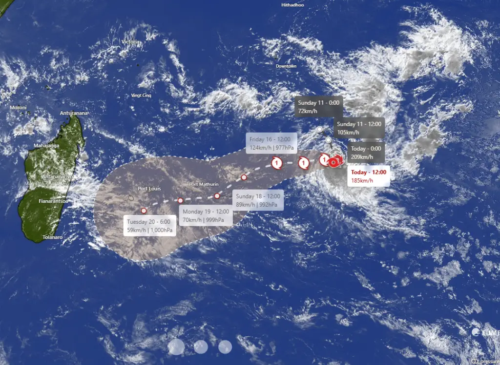
At 0900 UTC on 13 January 2026, Tropical Cyclone Dudzai was located near 17.3° South latitude and 78.0° East longitude, approximately 692 nautical miles south-southeast of Diego Garcia. The cyclone is nearly stationary, drifting southwestward at just 1 knot (about 2 km/h) over the past six hours.
Dudzai is currently producing maximum sustained winds of 100 knots (approximately 185 km/h), with gusts reaching up to 125 knots (around 230 km/h). The minimum central pressure is estimated at 954 millibars, indicating a very intense tropical system. Significant wave heights near the cyclone are estimated to be 27 feet (around 8.2 meters), creating extremely hazardous marine conditions.
Satellite and Structural Analysis of Cyclone Dudzai
Satellite imagery shows that Dudzai has undergone some structural degradation compared to previous advisories. Enhanced infrared and multispectral satellite imagery reveal warming cloud tops, a contracting area of deep convection, and an eye that is struggling to maintain a consistent shape. Despite these signs of weakening, the eye feature remains visible, allowing forecasters to determine the cyclone’s position with high confidence.
The weakening trend over the past 12 hours is attributed to increasing environmental challenges, including moderate vertical wind shear and dry air intrusion from the southwest. Nevertheless, objective and subjective satellite intensity estimates remain largely supportive of a major tropical cyclone, with several agencies still estimating intensities exceeding 100 knots.
Environmental Conditions of Cyclone Dudzai
Dudzai is currently embedded in a marginally favorable environment. Sea surface temperatures remain warm, between 27 and 28 degrees Celsius, which is sufficient to sustain tropical cyclone activity. Vertical wind shear is estimated at 10 to 15 knots, which is moderate but not yet strong enough to cause rapid weakening.
Outflow remains moderate, particularly toward the poleward side of the system. This poleward outflow is expected to play a critical role in determining whether Dudzai can temporarily regain strength later in the forecast period.
Forecast Track Outlook of Cyclone Dudzai
According to JTWC guidance, Tropical Cyclone Dudzai is expected to track westward through the next 72 hours, followed by a southwestward turn through day five. As the subtropical ridge to the south strengthens and expands westward, the cyclone should gradually gain forward speed while remaining over open ocean.
Track forecast confidence is high through 72 hours and medium beyond that period, with most numerical models in good agreement. One notable outlier, the NAVGEM model, suggests a sharper southward turn, but this solution is not favored by forecasters.
Forecast Intensity Trends of Tropical Cyclone Dudzai
Dudzai is forecast to continue weakening through the next 48 hours as moderate wind shear and dry air persistently disrupt the cyclone’s core. After this period, conditions may briefly improve between 48 and 96 hours, allowing the system a chance to stabilize or modestly re-intensify, aided by improved poleward outflow aloft.
Beyond 96 hours, however, environmental conditions are expected to deteriorate significantly. Increasing vertical wind shear and further dry air entrainment should force Dudzai back into a weakening trend, gradually reducing its intensity while it continues moving southwestward over the South Indian Ocean.
Intensity forecast confidence remains medium in the short term and low beyond 72 hours, reflecting uncertainty regarding how effectively favorable outflow may offset hostile atmospheric factors.
Marine Impacts and Safety Considerations
While Dudzai poses no immediate threat to land, it represents a serious hazard to maritime interests across the South Indian Ocean. Very high seas, violent winds, and dangerous swell patterns are expected to persist near the cyclone’s core for several days.
Vessels operating in the region should avoid the cyclone’s path and monitor official warnings closely. Even well away from the center, long-period swells may propagate across shipping lanes, creating hazardous conditions.
Summary of This Cyclone Update
Tropical Cyclone Dudzai remains a powerful and well-organized system, despite signs of gradual weakening. Its slow movement, strong winds, and large wave field make it a significant weather feature over the South Indian Ocean. Although no land impacts are expected at this time, continued monitoring is essential as environmental conditions evolve over the coming days.
Further updates will be issued by the Joint Typhoon Warning Center as the situation develops.
If You are in an old update, Check Latest (Click Here)
Advertisements