World Tropics This Week: February 06–12th, 2024
Current Situation:
01 Active tropical cyclones: As of today(6th Feb), there is 01 active tropical cyclones in Southern Pacific Ocean.
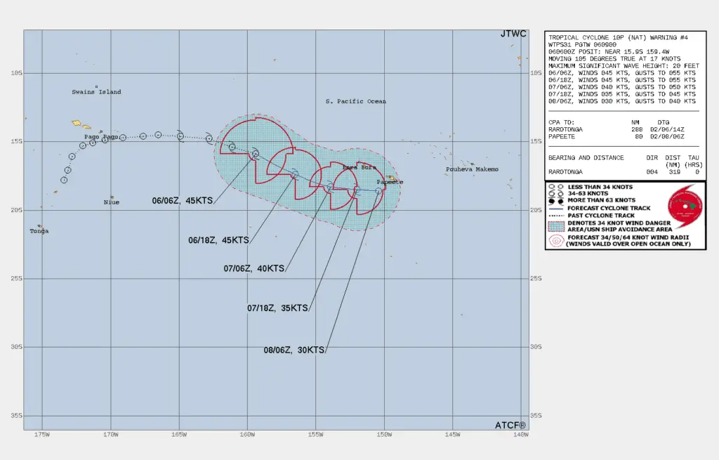
CYCLONE 10P (NAT) । Issued at 06 Feb/09:00 UTC(0)
SUMMARY:
   INITIAL POSITION: 15.9S 159.4W
   INITIAL INTENSITY: 45 KTS (1MIN)
   GEOGRAPHIC REFERENCE: 435 NM WEST OF BORA BORA
   MOVEMENT PAST 6 HOURS: EAST-SOUTHEASTWARD AT 17KTS
   SIGNIFICANT WAVE HEIGHT: 20 FEET
Else, there is no active cyclone in any of the global basins (Atlantic, Eastern Pacific, Central Pacific, Western Pacific, or North and Southern Indian Ocean).
Areas to Watch:
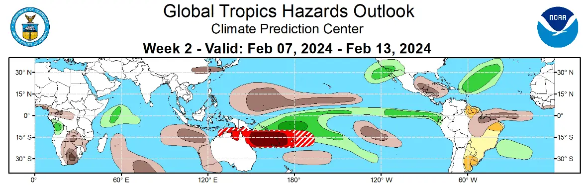
South Pacific: Enhanced convection associated with the Madden-Julian Oscillation (MJO) and a westerly wind burst (WWB) is expected to provide favorable conditions for multiple tropical cyclones development over the South Pacific Ocean this week. However, there is still uncertainty in the forecast, and it’s too early to definitively say whether or not more than one cyclone will form.
North Pacific: Strong subtropical westerly flow is forecast over the North Pacific, both near the surface and aloft. This could potentially lead to an atmospheric river event to affect the West Coast of the United States during the week.
Additional Resources: NOAA
JTWC 06 HOUR SUMMARY AND ANALYSIS OF CYCLONE 10P (NAT) AS ON 06 FEB 2024 AT 9 UTC(0)
Satellite Analysis, Initial Position And Intensity Discussion:
Animated multispectral satellite imagery (MSI) shows a medium-sized system embedded in the south pacific convergent zone that is fast approaching the strong westerlies as evidenced by transverse banding along the outflow cirrus to the south.
The cold dense overcast has deepened over the past six hours, punctuated by overshooting cloud tops. The initial position is placed with medium confidence based on low cloud tracing into an obscured circulation center in the MSI loop.
The initial intensity is placed with medium confidence based on the aggregate agency and automated Dvorak estimates and reflects the 6hr convective improvement. Analysis indicates a marginal environment with warm SST and strong poleward outflow offset by moderate to strong VWS.
Initial wind radii basis: persistence
Current steering mechanism: near-equatorial ridge (NER) to the north.
AGENCY DVORAK AND AUTOMATED FIXES:
PGTW: T3.0 – 45 KTS
CIMSS ADT: 49 KTS AT 060540Z
CIMSS AIDT: 38 KTS AT 060540Z
FORECASTER ASSESSMENT OF CURRENT ENVIRONMENT: MARGINAL
VWS: 20-30 KTS
SST: 30-31 CELSIUS
OUTFLOW: STRONG POLEWARD
ANALYSIS CONFIDENCE:
INITIAL POSITION: MEDIUM
INITIAL INTENSITY: MEDIUM
INITIAL WIND RADII: LOW
3. Forecast reasoning.
Significant forecast changes: There are no significant changes to the forecast from the previous warning.
Forecast discussion: TC NAT will continue on its current east-southeastward track under the steering influence of the NER for the remainder of the forecast. The marginal environment will sustain the current intensity, at best, up to 12hrs.
Afterward, increasing VWS and dry air entrainment at the low levels will gradually erode the system to dissipation by 48hrs possibly sooner.
Model discussion: numerical models are in tight agreement with a gradual and even spread to a mere 64nm by 48hrs, lending high confidence to the JTWC track forecast. There is only medium confidence in the intensity forecast, given the possibility of an earlier dissipation.
FORECAST CONFIDENCE:
TRACK 0 – 72 HR: HIGH
INTENSITY 0 – 72 HR: MEDIUM//
Advertisements