OHIO Weather and Midwest to have Tornado and Hail Warning Tuesday
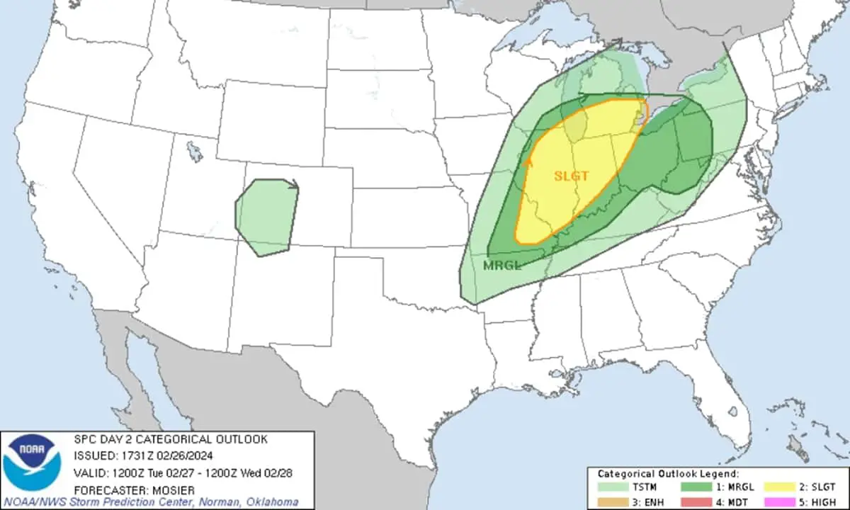
The National Weather Service’s Storm Prediction Center in Norman, Oklahoma, has issued a severe weather alert for parts of the Midwest. The alert is valid from Tuesday afternoon through the overnight hours.
According to this alert,OHIO Weather and Midwest to have Severe Thunderstorms and Tornado Risk with hails.
They warn of a slight risk of severe thunderstorms from east-central Missouri into Illinois, Indiana, northwest Ohio, and southern lower Michigan.
➡ Follow us on Google News feed for daily Latest Updates
Severe Thunderstorms and Tornado Alert for mid-Mississippi Valley to the Ohio Valley and southern Lower Michigan
Scattered strong to severe thunderstorms are expected, potentially bringing large hail, damaging gusts, and a few tornadoes.
This weather is anticipated to occur from late Tuesday afternoon into the evening and overnight hours, spanning from the mid-Mississippi Valley to the Ohio Valley and southern Lower Michigan.
WX Analysis of MidWest US weather
The upper pattern features a northern-stream shortwave trough over the northern Rockies, along with moderate to strong southwesterly flow extending from off the Baja coast into the Mid-South.
As this pattern evolves, a full latitude trough covering much of the central CONUS is expected by early Wednesday morning.
A surface low associated with this trough will deepen as it moves across the Upper Midwest and Upper Great Lakes. This will lead to notable mass response and low-level moisture advection through the Mississippi Valley.
Dewpoints in the upper 50s are expected to reach the Lower/Middle Ohio Valley and possibly Lower Michigan by Tuesday evening.
Regional Impacts of this Severe weather in Midwest
Thunderstorms are expected in the Upper Ohio Valley early Tuesday, supported by moderate low-level southwesterly flow and warm-air advection.
Some storms may become strong enough to produce hail, but storm intensity should diminish gradually with eastern extent.
Latest: Coastal NSW Weather to Have Increased Rainfall or TS Later this Week
New: Sydney Weather to have reduced rain earlier but increase later this week
Read More: North Western NT Weather may have Daily Rain Rest of This Month
See Also: Auckland Weather to have rain sun rain probability this week
Mid-MS Valley and Ohio Valley Weather
Throughout the day, the airmass across the Mid-MS Valley and Ohio Valley is expected to destabilize amid increasing low-level moisture and cooling mid-level temperatures.
Initial thunderstorm development is likely via warm advection, mainly north of the warm front. These storms could produce large to very large hail due to steep mid-level lapse rates and strong vertical shear.
Storm Development Along Cold Front
Another round of thunderstorms is expected along the cold front as it moves through the region. These storms may develop from western Illinois into east-central/southeast Missouri in the evening, then track eastward with the front.
The greatest potential for damaging gusts is anticipated across Illinois and Indiana, with storm intensity lessening as the system moves eastward into Ohio.
Precautionary measures for Severe weather in Ohio, Pennsylvania, Illinois, Indiana
Residents in the affected regions, including Illinois, Indiana, Ohio, and Pennsylvania, are advised to stay informed about weather updates and heed any warnings issued by local authorities.
Precautionary measures should be taken to ensure safety in the event of severe weather, including securing outdoor belongings and having a plan in place for seeking shelter if necessary.
Advertisements