Cyclone Megan Latest: Monster Cyclone Megan to Make Landfall over NT Coast Today
Tropical Cyclone Advisory: 4:00 am ACST [4:30 am AEST] on Saturday,18 March 2024
Intense Tropical Cyclone Megan nearing to coasts across Southwestern Gulf of Carpentaria. It is still a category 3 Cyclone at Australian scale. The Monster Cyclone Megan may cross the coast at peak intensity. As the cyclone maintains it’s monster strength, residents are urged to prepare and stay informed about potential hazards.
Details of Impact Area:
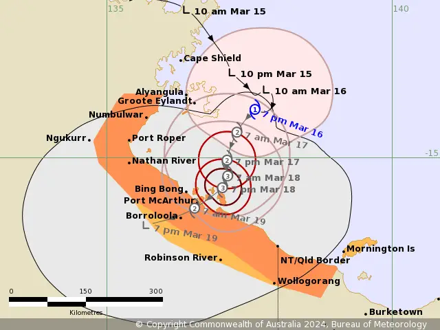
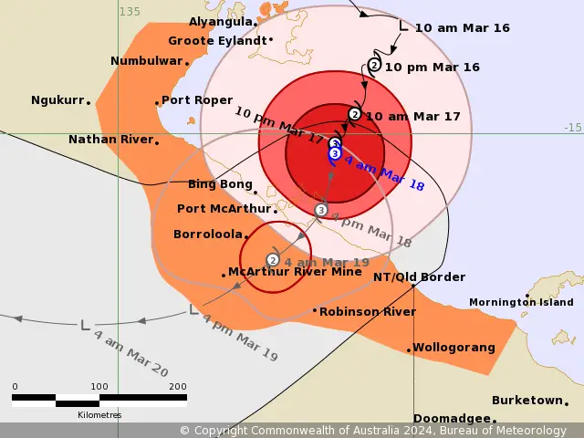
TC Megan Warning Zone: Includes Alyangula (Groote Eylandt) in the NT to Mornington Island in Qld (not including Mornington Island), extending inland to Borroloola, McArthur River Mine, and Robinson River, but not including Ngukurr.
TC Megan Watch Zone: None.
Cancelled Zone: No cancellations reported.
Details of Tropical Cyclone Megan
Intensity: Currently, Cyclone Megan still be classified as Category 3 (AU Scale). Maximum sustained winds near the center reaching 130 km/h (10 min) and gusts up to 185 km/h.
Location: Positioned within 30 kilometres of 15.2 degrees South 137.2 degrees East, estimated to be 170 kilometres south southeast of Alyangula and 135 kilometres northeast of Borroloola.
Movement: Slow moving in SW Direction.
Megan Forecast and Hazards for Northern Australia:
Tropical Cyclone Megan is projected to maintain intensity as it heads towards landfall. It may already have peak intensity.
Furthermore, Cyclone Megan is expected to cross the coasts today as a Monster Tropical Cyclone (Cat 3-AU scale). Landfall could be across southwestern Gulf of Carpentaria coast between Nathan River and the Northern Territory/Queensland border.
Once over land, Megan should weaken quickly as it tracks west through the Northern Territory.
Wind Risk Advisory of Megan
Damaging Wind Gusts: Gales with DAMAGING WIND GUSTS to 120 km/h will develop along the southwestern Gulf of Carpentaria coast between Nathan River and the NT/Qld border this morning before extending to inland areas including Borroloola, McArthur River Mine, and Robinson River during the day due to Cyclone Megan.
Gales with DAMAGING WIND GUSTS to 110 km/h are occurring over parts of Groote Eylandt, these are expected to begin to ease during this morning as Megan moves further away. These winds may extend further northwest to Numbulwar in the NT, or east to Mornington Island in Qld (not including Mornington Island), during today.
Destructive Wind Gusts: DESTRUCTIVE WIND GUSTS of Cyclone Megan in excess of 125 km/h are occurring about the Sir Edward Pellew Group and will extend to the southwestern Gulf of Carpentaria coast, between Nathan River in the NT and the NT/Qld border during today.
Very Destructive Core: The VERY DESTRUCTIVE CORE of Cyclone Megan, with wind gusts up to 200 km/h, will start to impact the coast between Bing Bong in the NT and the NT/Qld border in the next few hours and will continue throughout the day as the system slowly crosses the coast.
Intense Rainfall Warning
Intense Rainfall: Due to Cyclone Megan, HEAVY to locally INTENSE RAINFALL is likely about the southwestern Gulf of Carpentaria coast during today and may even occur about parts of the Gulf Country in Queensland. HEAVY RAINFALL will extend to adjacent inland areas in the Carpentaria forecast district as the system crosses the coast.
Storm Tide and Abnormally High Tides Warning:
Additionally, Coastal residents between Nathan River and the Northern Territory/Queensland border are specifically warned of a DANGEROUS STORM TIDE as the Cyclone Megan’s center crosses the coast. Tides are likely to rise significantly above the normal high tide, with DAMAGING WAVES and DANGEROUS FLOODING.
Abnormally high tides
Abnormally high tides are expected over remaining parts of the southern Gulf for the next few days, and will likely rise above the normal high tide at times.

Read Also:
Monster Cyclone Megan to Make Landfall Tonight
Cyclone Megan: Cyclone Threat for Coasts across Gulf of Carpentaria
Recommended Action to Overcome the Impact:
The Northern Territory Emergency Service urges residents in the vicinity of the Cyclone Warning to take immediate precautions. This includes securing loose items on your property without delay.
Additionally, it is vital to check on your neighbors to ensure they are adequately prepared for the impending weather conditions. Make necessary arrangements to take shelter as soon as possible, and remain vigilant by listening to updates and instructions from emergency services.
Queensland Fire and Emergency Services Advisory
Similarly, the Queensland Fire and Emergency Services (QFES) advises individuals situated between the Queensland/Northern Territory border and Mornington Island (excluding Mornington Island itself) to exercise caution and stay attuned to forthcoming guidance and updates.
If You are in an old update, Check new updates here (Click Me)
Advertisements