Cyclone Megan Latest: Monster Cyclone Megan to Make Landfall Tonight
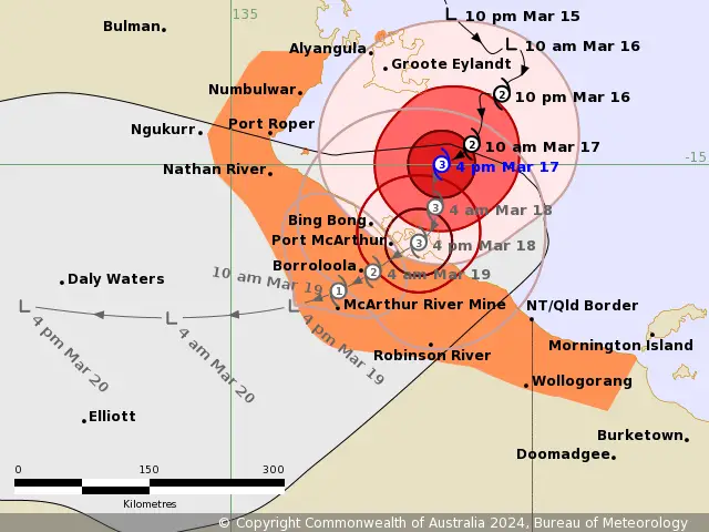
Tropical Cyclone Advisory: 5:50 pm ACST [6:20 pm AEST] on Saturday,17 March 2024
Impressively, Tropical Cyclone Megan has intensified rapidly over Gulf of Carpentaria. It is now a category 3 Cyclone at Australian scale. The Monster Cyclone Megan may cross the coast at peak intensity. It is prompting warnings and watches for various regions along the northern Australian coast. As the cyclone gains monster strength, residents are urged to prepare and stay informed about potential hazards.
Areas To be affected by Monster TC Megan:
TC Megan Warning Zone: Includes Alyangula (Groote Eylandt) in NT to Mornington Island in Qld (not including Mornington Island), extending inland to Borroloola, McArthur River Mine, and Robinson River, but not including Ngukurr.
TC Megan Watch Zone: None.
Cancelled Zone: No cancellations reported.
Details of Tropical Cyclone Megan
Intensity: Currently classified as Category 3 (AU Scale). Maximum sustained winds near the center reaching 125 km/h (10min) and gusts up to 165 km/h.
Location: Positioned within 30 kilometres of 15.0 degrees South 137.1 degrees East, estimated to be 150 kilometres south southeast of Alyangula and 145 kilometres northeast of Borroloola.
Movement: South southwest at 7 kilometres per hour.
Megan Forecast and Hazards for Northern Australia:
Tropical Cyclone Megan is projected to strengthen More as it heads towards landfall. It may potentially Peak by this evening/night.
Furthermore, Megan is expected to cross the coasts by Monday (early) as a Monster Tropical Cyclone (Cat 3-AU scale). Landfall could be across southwestern Gulf of Carpentaria coast between Nathan River and the Northern Territory/Queensland border.
Once over land, Megan should weaken quickly as it tracks west through the Northern Territory.
Wind Data of TC Megan
Damaging Wind Gusts: Residents in parts of Groote Eylandt are currently being experienced Gales with DAMAGING WIND GUSTS of 110 km/h. It is expected to persist for the remainder of Sunday.
Gales with DAMAGING WIND GUSTS to 110 km/h are occurring about the Sir Edward Pellew Group and beginning to encroach onto the adjacent mainland. These gales are expected to extend to further coastal mainland areas between Nathan River and the NT/Qld border this afternoon and evening. And also expected inland areas including Borroloola, McArthur River Mine, and Robinson River overnight or on Monday.
Gales with DAMAGING WIND GUSTS to 110km/h may extend further northwest to Numbulwar in the NT, or east to Mornington Island in Qld (not including Mornington Island), during the next 24 hours if Megan moves further west or east than forecast.
Destructive Wind Gusts: Destructive wind gusts exceeding 125 km/h are expected along the southwestern Gulf of Carpentaria coast from Nathan River to the NT/Queensland border as Cyclone Megan nears. Residents should prepare and heed official advisories.
Very Destructive Core: The VERY DESTRUCTIVE CORE of Megan, with wind gusts up to 200 km/h, is expected to cross the coast between Nathan River in the NT and the NT/Qld border during Monday.
Intense Rainfall Warning
Intense Rainfall: As well as INTENSE RAINFALL is possible about coastal parts of the Carpentaria District as Megan approaches later today and during Monday.
Also, HEAVY RAINFALL is occurring over southeastern parts of the Top End, with the heaviest falls in coastal and island locations. The heaviest falls will extend further inland during today in the Carpentaria forecast district as well as into parts of the Gulf Country coast in Queensland.
Storm Tide and Abnormally High Tides Warning:
Additionally, Coastal residents between Nathan River and the Northern Territory/Queensland border are specifically warned of a DANGEROUS STORM TIDE as the cyclone center crosses the coast. Tides are likely to rise significantly above the normal high tide, with DAMAGING WAVES and DANGEROUS FLOODING.
Abnormally high tides are expected over remaining parts of the southern Gulf for the next few days, and will likely rise above the normal high tide at times.

Read Also:
Cyclone Megan: Monster Cyclone Megan Developing across Gulf of Carpentaria
Cyclone Megan: Cyclone Threat for Coasts across Gulf of Carpentaria
Recommended Action to Overcome the Cyclone Megan Impact:
The Northern Territory Emergency Service urges residents in the vicinity of the Cyclone Warning to take immediate precautions. This includes securing loose items on your property without delay.
Additionally, it is vital to check on your neighbors to ensure they are adequately prepared for the impending weather conditions. Make necessary arrangements to take shelter as soon as possible, and remain vigilant by listening to updates and instructions from emergency services.
Similarly, the Queensland Fire and Emergency Services (QFES) advises individuals situated between the Queensland/Northern Territory border and Mornington Island (excluding Mornington Island itself) to exercise caution and stay attuned to forthcoming guidance and updates.
If You are in an old update, Check new updates here (Click Me)
Advertisements