Tropical Storm Mun Update – July 4, 2025, 3 PM UTC
The Joint Typhoon Warning Center (JTWC) has issued Prognostic Reasoning Warning Number 12 for Tropical Storm 04W (Mun) as of 3 PM UTC on July 4, 2025. The system continues to slowly intensify as it tracks northeastward over open waters well east of Japan. Let’s Take a look on the latest Tropical Storm Mun Update :
Current Position and Motion
-
Location: 30.2°N, 145.3°E
-
Distance: About 457 km northeast of Chichi Jima, Japan
-
Recent Movement: Northeast at 7 km/h over the past 6 hours
-
Significant Wave Height: 7.6 meters
Current Intensity as of Tropical Storm Mun Latest Update
-
Maximum Sustained Winds: 102 km/h (equivalent to 55 knots)
-
Environment: Favorable, with near-zero vertical wind shear and strong eastward outflow enhancing the system.
-
Sea Surface Temperature: 25–26°C
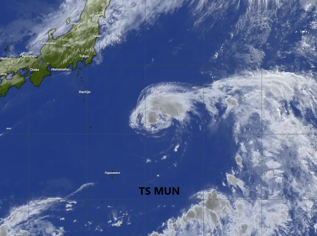
Satellite Analysis of Tropical Storm Mun
Enhanced infrared imagery shows a compact central dense overcast with deep convection still sheared southwest of the low-level circulation center (LLCC). A recent SAR pass confirmed a well-defined center with maximum winds near 100 km/h.
-
Dvorak Estimates: Range from 65 km/h to 102 km/h
-
CIMSS Automated Estimates: Range from 68 km/h to 100 km/h
Confidence in the storm’s current position and intensity remains medium due to partial exposure of the LLCC.

Steering Environment across Tropical Storm Mun
Mun is currently steered by a deep-layered subtropical ridge (STR) to its east and southeast. This setup will guide the storm northeastward for the next 36 hours towards a weakness in the ridge caused by an approaching upper-level trough.
Forecast Track and Intensity of the Potential Typhoon Mun
-
Next 24 hours: Modest intensification is forecast as the storm remains in a favorable upper-level environment but marginal sea surface temperatures (24–25°C) will limit rapid strengthening. Peak intensity could reach about 130 km/h (70 knots) by tomorrow.
-
36–96 hours: The system is expected to curve more northward as the STR rebuilds to the north. By TAU 96, Mun will start to interact with stronger subtropical westerlies.
-
Beyond 96 hours: The cyclone will weaken rapidly due to cold waters and high vertical wind shear (45–75 km/h) and begin extratropical transition.
- Follow us on Google News feed for daily Latest Updates
Model Guidance of Potential Typhoon Mun
-
Deterministic models agree well through 36 hours, then diverge significantly out to 120 hours.
-
The GFS has adjusted closer to the consensus track, while NAVGEM remains an outlier.
-
Ensemble spread (GEFS) remains broad, while the ECENS ensemble shows tighter clustering east of Japan.
-
Intensity models show a peak near 130–140 km/h, but there’s medium uncertainty due to varying upper-level conditions.
✅ Key Takeaways
✅ Current Winds: 102 km/h
✅ Possible Peak Winds: Up to 130 km/h in 24 hours
✅ Track: Moving northeast, then turning northward before weakening
✅ No direct threat to land at this time, but shipping interests in the northwest Pacific should monitor developments.
Update Time: July 4, 2025 — 3 PM UTC
Source: JTWC Prognostic Reasoning Warning NR 012 for TS 04W (Mun)
Stay tuned for the latest tropical cyclone updates from the Joint Typhoon Warning Center and local meteorological agencies.
If You are in an old update, Check new updates here (Click Me)
Advertisements