Severe Tropical Cyclone Narelle Threatens Western Australia: Destructive Winds, Flooding Rain, and Dangerous Storm Tide Expected
Update Time: 12:59 PM, Thursday, March 26, 2026 (GMT+8), WA Local Time, Australia
Severe Tropical Cyclone Narelle is intensifying offshore and moving along the western coast of Western Australia, bringing a dangerous combination of destructive winds, heavy rainfall, storm surge, and coastal flooding risks. Authorities are urging residents across the Pilbara and Gascoyne regions to prepare immediately as impacts are expected to escalate through Thursday, Friday, and into early Saturday.
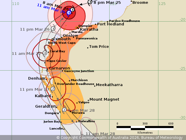
Cyclone Narelle Track and Affected Areas
Cyclone Narelle is forecast to track southward along the coast, impacting multiple key locations. Areas already experiencing severe conditions include coastal regions between Munda Station and Mardie, including Karratha. The system is expected to expand its impact zone significantly over the next 24–48 hours.
By Thursday afternoon, damaging winds and storm conditions are expected to extend westward toward Exmouth and eastward toward Port Hedland. By Friday, the cyclone’s effects will spread southward to Carnarvon, Denham, and inland regions including the Overlander Roadhouse.
Further expansion is possible into southern areas such as Kalbarri and even inland locations like Morawa by early Saturday.
Destructive Winds and Gale-Force Conditions
One of the most dangerous aspects of Cyclone Narelle is its wind field.
- Destructive wind gusts exceeding 125 km/h are expected in multiple coastal and inland regions, particularly late Friday and into Saturday.
- Gale-force winds with gusts up to 120 km/h are already occurring along coastal areas near Karratha and Mardie.
- Winds are forecast to spread southward and inland, potentially reaching Jurien Bay and Dalwallinu by Saturday morning.
These wind speeds are capable of causing significant structural damage, uprooting trees, downing power lines, and making travel extremely dangerous.
Heavy Rainfall and Flash Flood Risk of Cyclone Narelle
Cyclone Narelle is also expected to produce heavy to intense rainfall, significantly increasing the risk of flash flooding across affected regions.
- Heavy rainfall is expected across the western Pilbara and Gascoyne regions.
- Intense rainfall capable of severe flash flooding is likely to develop west of Onslow overnight and continue into Friday morning.
- These intense rain bands will gradually move southward into northwestern Gascoyne later on Friday.
Flood-prone and low-lying areas are particularly at risk. Rapid rises in water levels could occur with little warning, making conditions hazardous for residents and travelers.
Dangerous Storm Tide and Coastal Flooding
A major concern with Cyclone Narelle is the dangerous storm tide expected along the Gascoyne coast.
Residents between Onslow and Denham are specifically warned about:
- Abnormally high tides exceeding normal levels
- Damaging waves impacting coastal infrastructure
- Dangerous coastal flooding in low-lying areas
Between Port Hedland and Onslow, tides will also rise above normal levels, with large waves potentially causing minor flooding along the coast. Combined with strong winds, these conditions can lead to coastal erosion and significant property damage.
High-Risk Areas and Impact Timeline
Thursday Afternoon:
- Gale-force winds expand toward Exmouth and Port Hedland
- Coastal impacts intensify near Karratha and Mardie
Friday:
- Destructive winds extend south toward Carnarvon and Denham
- Intense rainfall spreads into Gascoyne
- Storm tide risk peaks along the coast
Saturday (Early Hours):
- Wind impacts may reach Kalbarri and Morawa
- Gales extend further south toward Jurien Bay
Safety Advice for Residents
Residents in affected regions should take immediate precautions:
- Secure loose outdoor items and prepare for strong winds
- Avoid coastal areas due to dangerous waves and storm surge
- Do not attempt to drive through floodwaters
- Stay updated through official weather warnings and emergency services
- Prepare emergency kits, including food, water, and essential supplies
Summary of the Cyclone Narelle Latest Update
Cyclone Narelle is shaping up to be a high-impact tropical system for Western Australia, with multiple hazards including destructive winds, severe rainfall, and coastal flooding. While the exact track may vary slightly, confidence remains high that large areas of the Pilbara and Gascoyne regions will experience dangerous conditions over the next 48 to 72 hours.
Residents are strongly advised to stay alert, follow official guidance, and take all necessary precautions as the situation continues to evolve. See More on BoM Website
If You are in an old update, Check Latest (Click Here)
Advertisements