Typhoon Kalmaegi Strengthens in the South China Sea, Aiming Toward Vietnam
Update Time: November 5, 2025 – 09:00 AM UTC (03:00 PM BST)
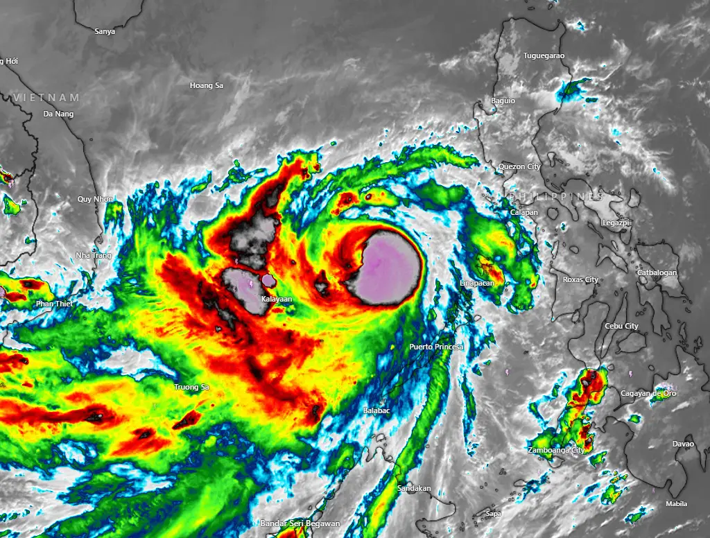
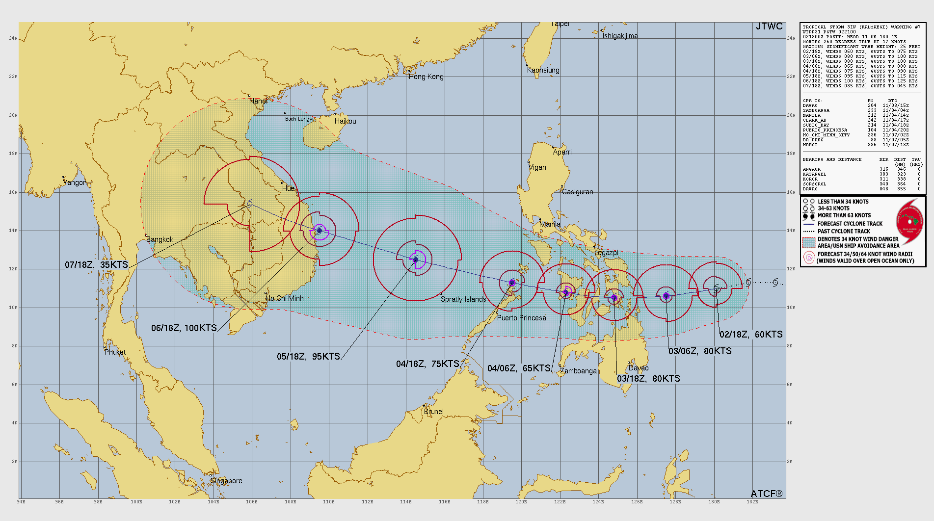
Typhoon Kalmaegi (31W) has re-intensified in the South China Sea and is now a powerful tropical cyclone tracking northwestward toward the coast of Vietnam. According to the Joint Typhoon Warning Center (JTWC), Kalmaegi was centered near 11.4°N, 119.1°E at 050000Z, approximately 687 nautical miles (1,272 km) east-southeast of Da Nang, Vietnam. The system is moving northwest at a speed of 9 knots (17 km/h).
Current Intensity and Structure of Typhoon Kalmaegi
At the time of the latest analysis, Typhoon Kalmaegi’s maximum sustained winds were estimated at 75 knots (139 km/h), with gusts reaching 90 knots (167 km/h). The minimum central pressure is around 980 millibars, and significant wave heights are near 19 feet (5.8 meters).
Satellite imagery and microwave observations show that Kalmaegi has developed a defined low-level eye structure, with strong convective bands wrapping into the center. The storm is exhibiting strong equatorward outflow and is embedded in a marginally favorable environment characterized by vertical wind shear of 10–15 knots and sea surface temperatures between 29–30°C, both supportive of further intensification.
Environmental and Steering Factors of Typhoon Kalmaegi
The typhoon is being steered by a subtropical ridge located to its north, guiding it on a northwestward trajectory. Water vapor imagery shows favorable diffluent flow aloft, which aids in ventilation and storm strengthening. However, some dry air intrusion is evident to the northwest, which may limit rapid intensification later in the forecast period.
Forecast Track and Intensity Outlook of Typhoon Kalmaegi
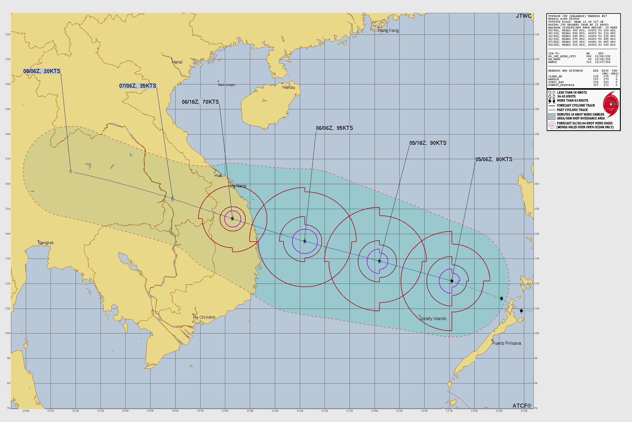
According to JTWC’s forecast reasoning, Typhoon Kalmaegi is expected to continue moving northwestward through the South China Sea. The storm environment remains favorable, and Kalmaegi is forecast to intensify further to peak at 100 knots (185 km/h) within the next 24 hours. This would make it equivalent to a Category 3 hurricane on the Saffir–Simpson scale.
-
By 12 hours (051200Z): Located near 12.2°N, 116.5°E with maximum sustained winds of 85 knots (157 km/h) and gusts to 105 knots (194 km/h).
-
By 24 hours (060000Z): Forecast position near 13.0°N, 113.4°E with peak intensity of 100 knots (185 km/h) and gusts up to 125 knots (231 km/h).
-
By 36 hours (061200Z): Expected near 13.8°N, 110.3°E with winds decreasing slightly to 95 knots (176 km/h) as vertical wind shear increases before landfall.
-
By 48 hours (070000Z): Projected to make landfall near 14.8°N, 107.5°E, weakening to 65 knots (120 km/h) over land.
-
By 72 hours (080000Z): Expected to dissipate inland near 15.9°N, 103.5°E, with remnant winds of 20 knots (37 km/h).
Forecast Confidence and Model Agreement
Model guidance remains in good agreement, with a narrow cross-track spread of about 50 nautical miles (93 km) at the projected landfall point, providing high confidence in the current forecast track. The intensity models also align well, suggesting a peak range of 85–115 knots (157–213 km/h), with multiple rapid intensification indicators triggered.
This means that Kalmaegi has a high probability of strengthening rapidly within the next 24 hours, supported by warm sea surface temperatures and efficient outflow aloft.
Potential Impacts and Regional Threats
If the current forecast holds, Typhoon Kalmaegi is expected to bring strong winds, torrential rainfall, and high surf to coastal regions of central and southern Vietnam starting late November 6 or early November 7. The system’s forward speed and moisture-laden core suggest a threat of widespread flooding, flash floods, and landslides, especially across Da Nang, Quang Nam, and Quang Ngai provinces.
Marine conditions will remain hazardous across the central South China Sea, with wave heights exceeding 6 meters and wind gusts over 160 km/h near the storm’s center. All maritime and coastal activities are advised to remain suspended until the system weakens after landfall.
Summary
-
Storm Name: Typhoon Kalmaegi (31W)
-
Current Location: 11.4°N, 119.1°E
-
Intensity: 75 knots (139 km/h), gusts 90 knots (167 km/h)
-
Pressure: 980 mb
-
Movement: Northwest at 9 knots (17 km/h)
-
Peak Forecast Intensity: 100 knots (185 km/h) within 24 hours
-
Landfall Expectation: Central Vietnam between 36–48 hours (Nov 6–7)
-
Dissipation Forecast: Over Laos within 72 hours
Typhoon Kalmaegi continues to pose a significant threat to maritime and coastal regions in the South China Sea and central Vietnam. With conditions favorable for additional strengthening, residents and authorities are urged to closely monitor official forecasts and prepare for possible severe weather conditions.
Advertisements