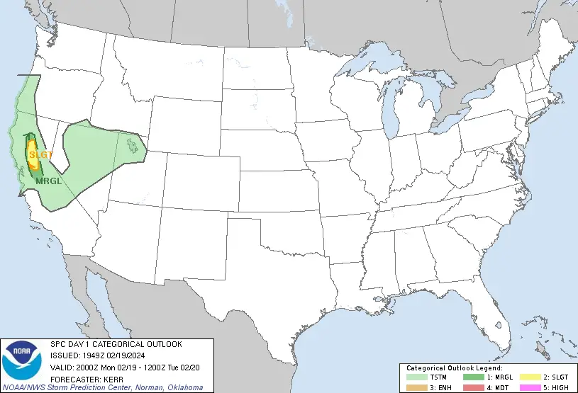
US Weather: Severe Thunderstorm and Tornado Alert for Northern CA
Update: 11:46 AM (PST) California, 1:40 PM (CST) Central Time, February 19, 2024
The US National Weather Service’s Storm Prediction Center in Norman, Oklahoma, has issued a severe weather alert for portions of the Sacramento Valley in central to northern California, US.
The alert is valid from 10:30 AM CST on February 19th to 6:00 AM CST on February 20th 2024.
On California Standard Time: 8:30 AM PST, 19th February to 4:00 AM PST, 20th February 2024.
Potential Risks of Severe Thunderstorm in California
There is a slight risk of severe thunderstorms in the northern California region. Also have a possibility of a tornado or two occurring.
Synopsis around California, US
A significant mid-level trough and accompanying surface low are affecting the West Coast. It is leading to the transport of moisture over California and the southern portion of the Pacific Northwest.
This setup is creating conditions conducive to severe weather, particularly in central to northern California.
Factors Contributing to Severe Weather in California
Cooler mid-level temperatures moving inland from the California coast, along with marginal buoyancy, are already present in the region.
As the day progresses, increased insolation will further enhance buoyancy, creating an environment supportive of organized thunderstorms.
Specific Reason for Thunderstorms in Central to Northern CA
In central to northern California, warm-air advection at lower levels is causing surface temperatures to rise. Accordingly, surface dew points reaching the 52-54°F range.
This, combined with mid-level lapse rates exceeding 7.5°C/km, is leading to the development of tall but thin Surface-Based Convective Available Potential Energy (SBCAPE) in the range of 500-750 J/kg.
Risk Factors for Tornado Alert in Northern CA
The presence of a curved low-level hodograph and significant 0-3 km storm-relative helicity (SRH) suggests favorable conditions for tornado development.
However, the likelihood of tornadoes is contingent upon surface dew points reaching 53-54°F to efficiently ingest SRH for tornadogenesis.
Also Check: Sydney Weather: Daily Thunderstorms in forecast for a Couple of Days
More to check: NSW Weather: Severe Thunderstorm Warning for Multiple NSW Districts
Cyclone lincoln: Cyclone Lincoln: May Re-intensify Wednesday off Kimberley Coast
Cyclone 16S: Mauritius Weather: Tropical Cyclone 16S to Pose a Risk of Landfall
Final Forecast Outcome for Thunderstorms in California
This afternoon and evening, there’s a slight risk of severe thunderstorms in interior Northern California, especially in parts of the Sacramento Valley. A few strong storms may develop by late afternoon, with the possibility of producing a tornado or two.
While it’s uncertain if there will be enough upward motion to support many storms, the conditions still favor the chance of a low-topped supercell capable of generating brief tornadoes.
Advertisements